Category: System Overview

  • 2014-03-27 Cospas-Sarsat assists in saving 6 lives per day!

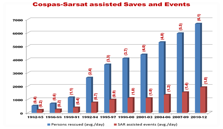
    Recent statistics show that the number of Cospas-Sarsat assisted saves have increased to an average of 6 lives saved per day over the past three years, up from 5 per day for the previous 6 years. This number is based on a 3 year average, as shown in the table below.

    Congratulations to all the hard-working people who make this great programme possible!


    SavesGraph


  • 2014-03-21 Costly Chopper Prank

    Crowds gathered at a cliff in New South Wales, Australia, to watch pilot Richard Nest and his crew home in and land in response to what turned out to be a prankster’s distress beacon signal. The beacon, likely stolen from a vessel, was activated and thrown from the Forster breakwall.

    Rescuers had to retrieve and shut off the beacon to prevent disruptive messages from continuing to alert satellites and distract commercial aircraft.

    The “malicious prank” falsely mobilized the three-man Westpac Rescue Helicopter crew and local Marine Rescue personnel, costing taxpayers up to $8000.

    Read more here:
    http://www.greatlakesadvocate.com.au/story/2058632/costly-chopper-prank/?cs=445

  • 2014-02-28 Keeping safe at sea

    Learn more about how Cospas-Sarsat beacons can help keep fishermen safe at sea and assist Search and Rescue teams.

    Read more here:

    http://www.worldfishing.net/news101/products/safety-and-distress/keeping-safe-at-sea 

  • Daniel Lévesque, Former Cospas-Sarsat Secretariat Head, Announced as MSUA 2014 Pioneer Award Winner

    The Mobile Satellite Users Association (MSUA) on Wednesday, February 26, 2014 announced that its 2014 Pioneer Award would be given to Mr. Daniel Lévesque, former head of the Cospas-Sarsat Secretariat, for his lasting contributions in key leadership roles in the Cospas-Sarsat Program.

    MSUA President Tim Farrar noted: “We are honored to recognize Mr. Daniel Lévesque as recipient of this year’s Pioneer Award. Mr. Lévesque not only served as the chief executive of Cospas-Sarsat for nearly a quarter of a century, but his outstanding leadership and technical skills have guided the program from its early days of depending only on analogue beacons operating through low earth orbiting satellites to the present. Cospas-Sarsat is credited with being the vital alert and location-determination link for helping to rescue more than 35,000 persons over more than three decades.”

    The award will be presented at a luncheon on Tuesday, 11 March 2014, during the MSUA-11 Conference that is being held in conjunction with the SATELLITE 2014 Conference and Exhibition, in Washington, DC.

    Read more about MSUA here:
    http://www.msua.org/

  • Cospas-Sarsat assisted as only alerting medium in rescue mobilised by activated black-market EPIRB

    Unable to raise search parties from either Somalia or Djibouti, the UKMCC urged the UK Maritime Trade Organization to step in and search for a UK-coded EPIRB off their coast. Anti-piracy forces in the area were mobilised, including a Japanese maritime patrol aircraft (MPA) that saw only the flashing beacon, followed by a Spanish helicopter launched from a frigate, which found 8 people in the water, their vessel having been sunk without a trace.

    The survivors were Yemeni nationals and had been the crew of a dhow which had sunk. All the crew were recovered. It is believed that the beacon was on a UK registered ship which was scrapped several years ago and the EPIRB had been sold on the black market. However the beacon happened to be on that vessel it was fortunate that the UKMCC operator pushed for a search. Without his diligence these men would surely have died. This alert also showed the multi-national cooperation that is often required during distress alerts and SAR.

  • Quick Statistics

     These statistics are copied from the latest issue of the System Data document, which is available here: http://www.cospas-sarsat.int/en/documents-pro/system-data.


    As of December 2015 the Cospas-Sarsat System had provided assistance in rescuing at least 41,750 persons in over 11,788 SAR events.

    As of April 2017:

    Governments and Agencies that are Cospas-Sarsat Programme “Participants”


    4 Parties to the Cospas-Sarsat Agreement

    29 Ground Segment Providers

    9 User States

    2 Participating Organisations

    Total = 44 Participants


    The Components of the Cospas-Sarsat System

    Distress Beacons Worldwide about 2,000,000

    Ground Segment

    Mission Control Centres (MCCs): 30

    LEOLUTs: 53

    GEOLUTs: 21

    Space Segment 

    LEOSAR satellites: 5

    GEOSAR satellites: 5


    System Operation

    A more detailed description of the System status is provided in the Cospas-Sarsat “System Data” document available on our Professionals website (Pro/Documents). 

    This document includes:

    • Statistics on the number of SAR events assisted by Cospas-Sarsat, and the number of lives rescued in these events

    • Maps depicting LEOSAR and GEOSAR coverage

    • The list of countries and organisations which participate in the management of the Programme and System operation

    • Space and ground segment equipment availability

    • The list of type approved 406 MHz beacons and beacon manufacturers

    • Estimated beacon population


  • Statistics

    These statistics are copied from the latest issue of the System Data document, which is available here: http://www.cospas-sarsat.int/en/documents-pro/system-data.

    Geographic Distribution of Confirmed SAR Events for which Cospas-Sarsat Data was Used

    (January to December 2015)

    Geogr Dist SAR 2015

    Distribution of SAR Events Assisted by Cospas-Sarsat by Type of Events
    (January to December 2015)


     Type of SAR Events 2015


    Persons Rescued by Type of SAR Event Assisted by Cospas-Sarsat 
    (January to December 2015)

    Persons Rescued 2015

    Number of SAR Events and Persons Rescued with the Assistance of Cospas-Sarsat Alert Data

    (121.5 and 406 MHz)

    (January 1994 to December 2015)

    Persons Rescued 2015 bar Graph

    Number of SAR Events Assisted 

    by Cospas-Sarsat (January to December 2015)

    Number of SAR Events 2015 Bar Graph


  • Cospas-Sarsat System

    The basic Cospas-Sarsat concept is illustrated in the adjacent figure. The System is composed of:

    • distress radiobeacons (ELTs for aviation use, EPIRBs for maritime use, and PLBs for personal use) which transmit signals during distress situations;

    • instruments on board satellites in geostationary and low-altitude Earth orbits which detect the signals transmitted by distress radiobeacons;

    • ground receiving stations, referred to as Local Users Terminals (LUTs), which receive and process the satellite downlink signal to generate distress alerts; and

    • Mission Control Centers (MCCs) which receive alerts produced by LUTs and forward them to Rescue Coordination Centers (RCCs), Search and Rescue Points Of Contacts (SPOCs) or other MCCs.

    The Cospas-Sarsat System includes two types of satellites:

    • satellites in low-altitude Earth orbit (LEO) which form the LEOSAR System
    • satellites in geostationary Earth orbit (GEO) which form the GEOSAR System

    The future Cospas-Sarsat System will include a new type of satellite in the medium-altitude Earth orbit (MEO) which will form the MEOSAR System. 

    Additional information on the three satellite systems, the LUTs, and the MCCs is provided in the tabs below. 

     [module-203]

  • Transition to MEOSAR (White Paper)


    [pdf version]

    Introduction

    The International Cospas-Sarsat Programme initiated the development of the Medium-altitude Earth Orbiting Satellite System for Search and Rescue (MEOSAR system) in 2004, with SAR repeaters placed on the satellites of the Global Navigation Satellite Systems (GNSS) of Europe (Galileo), Russia (Glonass) and the USA (GPS). Early operational capability (EOC) data from the MEOSAR system will be available from late-2016 and full operational capability (FOC) of the system is anticipated in 2018. MEOSAR will initially complement the existing LEOSAR (satellites in low-altitude orbits) and GEOSAR (satellites in geostationary orbit) systems, and will eventually replace the LEOSAR system.

    The Cospas-Sarsat System

    The Cospas-Sarsat System is comprised of:

    • distress radiobeacons (ELTs for aviation use, EPIRBs for maritime use, and PLBs for personal use) which transmit signals during distress situations,
    • instruments on board satellites which detect the signals transmitted by distress radiobeacons,
    • ground receiving stations, referred to as Local Users Terminals (LUTs), which receive and process the satellite downlink signal to generate distress alerts, and
    • Mission Control Centers (MCCs) which receive alerts produced by LUTs and forward them to Search and Rescue Points of Contacts (SPOCs).

    The current operational Cospas-Sarsat System includes two types of satellites:

    • satellites in low-altitude Earth orbit (LEO) which form the LEOSAR System,
    • satellites in geostationary Earth orbit (GEO) which form the GEOSAR System.

    The future Cospas-Sarsat System will include satellites in medium-altitude Earth orbit (MEO). Once fully operational, the MEOSAR system will provide global coverage and near-real-time beacon detection and independent location.

    The MEOSAR System

    Global Navigation Satellite System (GNSS) satellites orbit the Earth at an altitude between 19,000 and 23,000 km, a range considered as medium-altitude Earth orbit. Hence this component of Cospas-Sarsat is known as the Medium-altitude Earth Orbit Search and Rescue system, or MEOSAR. It will complement the existing LEOSAR and GEOSAR systems.

    The current LEOSAR and GEOSAR systems that detect and locate distress beacons have shortcomings that MEOSAR will overcome. The GEOSAR system constantly covers the entire Earth except the high-latitude (i.e., polar) regions. While the GEOSAR system can receive beacons distress messages across most of the globe, it cannot locate a beacon unless the location is encoded in the beacon’s message from a local navigation (GNSS) receiver. The LEOSAR system can locate a beacon without location information being transmitted in the beacon message (or can confirm the location even if positon information is transmitted in the beacon message), but the LEOSAR satellites have a view of only a small part of the Earth at any given time, which at times creates a delay in the distress signal reaching a ground station. While LEOSAR and GEOSAR still provide valuable search-and-rescue capabilities, MEOSAR is a revolution in technology.

    Once fully operational, the MEOSAR system will offer the advantages of both the LEOSAR and GEOSAR systems without their limitations by providing transmission of the distress message and independent location of the beacon, with near-real-time worldwide coverage. The MEOSAR system will facilitate other planned enhancements for Cospas-Sarsat beacons, such as a return-link-service (RLS) transmission to a distress beacons that will provide, for example, the user with a confirmation that the distress message has been received.

    The large number of MEOSAR satellites that will be in orbit when the system is fully operational will allow each distress message to be relayed at the same time by several satellites to several ground antennas, improving the likelihood of quick detection and improving the accuracy of the location determination.

    At the beginning of 2013, Cospas-Sarsat entered a Demonstration and Evaluation (D&E) phase for the MEOSAR system to show that MEOSAR performance meets expectations, and that distress alerts received by SAR authorities from the MEOSAR system have the required reliability and accuracy.

    The MEOSAR early operational capability (EOC), where distress alerts provided by the MEOSAR system are provided to SAR authorities for operational use, began in December 2016. The EOC phase will be followed by the initial operational capability (IOC) phase that will provide improved MEOSAR performance. When enough MEOSAR satellites and commissioned ground stations (MEOLUTs) are available to provide worldwide, near-real-time coverage, the MEOSAR system will be declared at full operational capability (FOC), which is anticipated in 2018.

    The MEOSAR System Concept

    MEOSARSystemConcept

This site is registered on wpml.org as a development site. Switch to a production site key to remove this banner.