Category: Uncategorised

  • Mission Control Centres (MCCs)

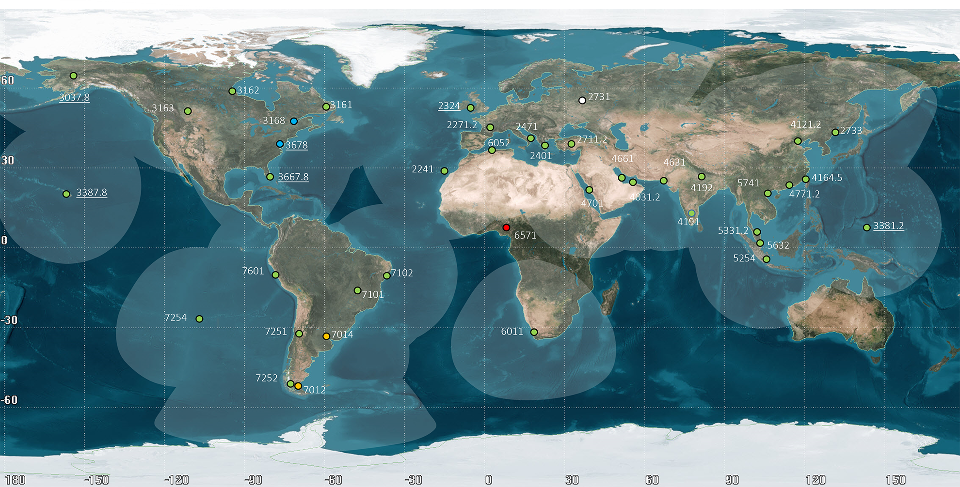
    [ List and map of MCCs ]

    [ MCC Contact Information ]

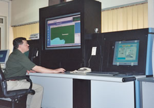
    MCCs have been set up in most countries operating at least one LUT. Their main functions are to:

    • collect, store and sort the data from LUTs and other MCCs;

    • provide data exchange within the Cospas-Sarsat System; and

    • distribute alert and location data to associated RCCs or SPOCs.

    Most of the data fall into two general categories : alert data and system information.

    Alert data is the generic term for Cospas-Sarsat 406 MHz data derived from distress beacons. 406 MHz beacons alert data comprise the beacon location and coded information.

    System information is used primarily to keep the Cospas-Sarsat System operating at peak effectiveness and to provide users with accurate and timely alert data. It consists of satellite ephemeris and time calibration data used to determine beacon locations, the current status of the space and ground segments and coordination messages required to operate the Cospas-Sarsat System.

    All MCCs in the System are interconnected through appropriate networks for the distribution of System information and alert data. To ensure data distribution reliability and integrity, Cospas-Sarsat has developed MCC performance specifications (document C/S A.005) and MCC commissioning procedures (document C/S A.006). Reports on MCC operations are provided by MCC Operators on an annual basis. World-wide exercises are performed from time to time to check the operational status and performance of all LUTs and MCCs, and data exchange procedures.


  • Acronyms and Terminology

    Acronym 

    Term

    Definition

    A/D

    Analogue/Digital


    ACC

    Area Control Centre


    ACHA

    Advisory Committee on the History of Cooperation in Space Activities 


    AEMCC

    United Arab Emirates MCC


    AFTN

    Aeronautical Fixed Telecommunication Network


    AGC

    Automatic Gain Control


    AI

    Action Item


    AIS

    Automatic Identification System


    ALC

    Automatic Level Control


    ALE Average Location Error  
    ALMCC Algerian MCC  
    AM Amplitude Modulation  
    AMSA Australian Maritime Safety Authority  
    AMSS Aeronautical Mobile-Satellite Service  
    AOS Acquisition of Signal  
    APSAR/TF Asia/Pacific Search and Rescue Task Force  
    ARCC Aeronautical Rescue Coordination Centre  
    ARMCC Argentine MCC  
    ASMCC  South African MCC   
    ATC Air Traffic Control  
    AUMCC Australian MCC  
    Az Azimuth  
    BASARNAS National SAR Agency of Indonesia   
    BCD Binary-Coded Decimal  
    BCH Bose-Choudhuri-Hocquenghem  
    BCN Beacon  
    BER Bit Error Rate  
    BIH Bureau International de l’Heure  

    bps

    Bits per second

    Bits par seconde


    BRMCC

    Brazilian MCC


    BW

    Bandwidth


    C/N

    Carrier-to-Noise Ratio


    C/N0

    Carrier-to-Noise Density Ratio


    C/S

    Cospas-Sarsat


    CDA

    Command and Data Acquisition Station (NOAA)


    CDARS

    Cooperative Data and Rescue Services


    CDDR

    Central DDR


    CDR

    Critical Design Review


    CEP

    Circular Error Probable


    CHMCC

    Chilean MCC


    CIRM

    Comité International Radio-Maritime

    International Radio-Maritime Committee

    CISPR

    International Special Committee on Radio Interference


    CLD

    Closed 

    Closed Meeting of a CSC Session

    CMC

    Cospas Mission Centre (Russian Federation)


    CMCC

    Canadian MCC


    CNES

    Centre National d’Etudes Spatiales (France)


    Cospas

    “Cosmicheskaya Sistyema Poiska Avariynich Sudov”

    Russian words meaning “Space System for the Search of Vessels in Distress”

    Système spatial pour les recherches des navires en détresse (sigle dérivé du russe)

    CSC

    Cospas-Sarsat Council

    Conseil Cospas-Sarsat

    dB

    Decibel

    Décibel


    DND

    Department of National Defence (Canada)

    Ministère de la Défense nationale (Canada)

    ELT

    Emergency Locator Transmitter

    Aeronautical distress beacon

    Emetteur de localisation d’urgence (balises de détresse aéronautiques)


    Ephémérides

    Données relatives à la position et à la vitesse du satellite qui permettent le calcul des positions du satellite à tout instant


    Ephemeris

    Satellite position and velocity data that allows the satellite position to be calculated at any point in time

    EPIRB

    Emergency Position Indicating Radio Beacon

    Maritime distress beacon

    Radiobalise de localisation de sinistre (RLS – balises de détresses maritimes)

    GEOLUT

    Geostationary Earth Orbit Local User Terminal

    A Ground receiving station in the Cospas-Sarsat GEOSAR System that detects, processes, and recovers the coded transmissions of 406 MHz emergency distress beacons, and relays the appropriate information to an MCC

    Station de réception au sol dans le système GEOSAR Cospas-Sarsat, qui détecte, traite et récupère les émissions codées des balises de détresse à 406 MHz, et relaie les informations adéquates à un MCC

    GEOSAR

    Geostationary Earth Orbit Search and Rescue

    Satellite system at 406 MHz

    Système de satellites géostationnaires à 406 MHz pour les recherches et le sauvetage

    Hz

    Hertz


    ICAO

    International Civil Aviation Organization

    Organisation de l’Aviation Civile Internationale (voir OACI)

    IMO

    International Maritime Organization

    Organisation Maritime Internationale (voir OMI)

    ITU

    International Telecommunication Union

    Union Internationale des Télécommunications (voir UIT)

    kHz

    Kilohertz


    LEOLUT

    Low Earth Orbit Local User Terminal

    A ground receiving station in the Cospas-Sarsat LEOSAR system that detects, characterises and locates emergency beacons, and forwards the appropriate information to an MCC

    Station de réception au sol dans le système LEOSAR Cospas-Sarsat, qui détecte, identifie et localise les balises de détresse, et envoie les informations adéquates à un MCC

    LEOSAR

    Low Earth Orbit Search and Rescue

    Satellite system in polar orbit

    Système de satellites en orbite polaire basse pour les recherches et le sauvetage

    LUT

    Local User Terminal

    Cospas-Sarsat ground receiving station

    Station terrienne d’utilisateur local (station Cospas-Sarsat de réception au sol)

    MCC

    Mission Control Centre

    Cospas-Sarsat Mission Control Centre

    Centre de contrôle de mission Cospas-Sarsat

    MHz

    Megahertz

    Mégahertz

    Radio frequency

    Fréquence radio


    MORSVIAZSPUTNIK

    Russian agency responsible for maritime navigation and mobile satellite communications at sea and on land

    NOAA

    National Oceanic and Atmospheric Administration (USA)


    NSS

    National Search and Rescue Secretariat (Canada)

     Secrétariat National – Recherche et Sauvetage (Canada), voir SNR

    OACI

    Organisation de l’Aviation Civile Internationale

    International Civil Aviation Organization (see ICAO)

    OMI

    Organisation Maritime Internationale

    International Maritime Organization (see IMO)

    PAIS

    Primary Air Information Stations


    PLB

    Personal Locator Beacon

    Balise de localisation personnelle

    RCC

    Rescue Coordination Centre

    Centre de coordination de sauvetage

    RF

    Radio Frequency


    RLS

    Radiobalise de localisation de sinistre

    Balises de détresses maritimes, voir aussi EPIRB

    RSFTA

    Réseau du service fixe des télécommunications aéronautiques


    SAIS

    Secondary Air Information Stations


    SAR

    Search and Rescue

    Recherches et Sauvetage

    SARP

    Search and Rescue Processor

    Processeur SAR

    Sarsat

    Search and Rescue Satellite-Aided Tracking

    Système d’aide aux recherches et au sauvetage par satellite

    SEU

    Single Event Upset


    SNR

    Secrétariat National – Recherche et Sauvetage (Canada)

    National Search and Rescue Secretariat (Canada), see NSS

    SPOC

    SAR Point of Contact

    Point de contact SAR

    SRR

    Search and Rescue Region

    Région de responsabilité SAR

    UIT

    Union Internationale des Télécommunications

    International Telecommunication Union (see ITU)

    А

    АРБ (EPIRB)

    Аварийный радиобуй-указатель местоположения (морской аварийный радиобуй)

    А

    АРМ (ELT)

    Аварийный передатчик-указатель положения (авиационный аварийный радиобуй)

    А

    АФТН (AFTN)

    Сеть авиационной фиксированной связи

    Б

    бит/сек (bps)

    Бит в секунду

    Г

    ГЕOСПОИ (GEOLUT)

    Наземная приемная станция в Системе Коспас-Сарсат ГССПС, которая обнаруживает и обрабатывает закодированные сообщения от аварийных радиобуев 406 МГц, а также передает соответствующую информацию в КЦС

    Г

    ГОСПС (GEOSAR)

    Геостанционарная спутниковая система поиска и спасания (406 МГц)

    Г

    Гц (Hz)

    Герц

    Д

    ДБ (dB)

    Децибел

    Д

    ДНД (DND)

    Министерство национальной обороны Канады

    И

    ИКАО (IMO)

    Международная организация гражданской авиации

    И

    ИМО

    Международная морская организация

    К

    КГц (kHz)

    Килогерц

    К

    КНЕС (CNES)

    Национальный центр по исследованию космоса (Франция)

    К

    Коспас (Cospas)

    Космическая система поиска аварийных судов (Россия)

    К

    КЦС (МСС)

    Координационный центр системы

    М

    МГц (MHz)

    Мегагерц

    М

    Морсвязьспутник (Morsvizsputnik)

    Государственное предприятие электронавигации и спутниковой связи Министерства транспорта и связи (Россия)

    М

    МСЭ (ITU)

    Международный союз электросвязи

    Н

    НИОСПОИ (LEOLUT)

    Наземная приемная станция в системе Коспас-Сарсат НССПС, которая обнаруживает и определяет местоположение аварийных радиобуев, а также передает соответствующую информацию в КЦС

    Н

    НОАА (NOAA)

    Национальное управление по океанам и атмосфере (США)

    Н

    НСС (NSS)

    Национальный Секретариат по поиску и спасанию (Канада)

    Н

    НССПС (LEOSAR)

    Низкоорбитальная спутниковая система поиска и спасания (с приполярной орбитой спутников)

    П

    ПОСПС (SARP)

    Процессор обработки сигналов поиска и спасания

    П

    ПРБ (PLB)

    Персональный радиобуй (аварийный радиобуй для использования на суше)

    П

    ПС (SAR)

    Поиск и спасание

    П

    ПСР (SRR)

    Поисково-спасательный район

    Р

    РЧ (RF)

    Радиочастота

    С

    Сарсат (Sarsat)

    Спутниковая система поиска и спасания

    С

    СКС (CSC)

    Совет Коспас-Сарсат

    С

    СКЦ (RCC)

    Спасательно-координационный центр

    С

    СПОИ (LUT)

    Станция приема и обработки информации (наземная приемная станция Коспас-Сарсат)

    Т

    ТКПС (SPOC)

    Точка контакта для поиска и спасания

    Э

    Эфемериды (Ephemeris)

    Данные о перемещении спутника и его скорости, которые позволяют рассчитать его положение в любой момент времени

  • Beacon Regulations Handbook

    Document C/S S.007 provides information concerning:

    • the status of 406 MHz beacon regulations in specific countries;

    • points of contact for beacon registration matters in various countries; and

    • extracts of some international regulations pertaining to 406 MHz beacons.

    C/S Ref.

    Document Title

    Dated

    S.007

    Handbook of Beacon Regulations

    Issue 1 – Revision 4

    Sept. 2013

    beacon

    NOTES:

    • Copies of beacon registration forms for some countries are available at the Secretariat upon request.

    • Satellite processing of 121.5 MHz emissions ceased on 1 February 2009 [read more].   Document C/S S.007 was updated accordingly.

  • LEOSAR Satellite Coverage


    The Cospas-Sarsat LEOSAR system provides global coverage for 406-MHz beacons. Light-blue areas on the figure above show areas where LEOSAR satellites and operational LEOLUTs have mutual visibility. When a satellite is actively tracked, detected beacons have their signals directly relayed to the tracking LEOLUT for processing. When a satellite is outside a light-blue area and detects beacons, detected beacon signals are processed, data is stored and sent over the downlink, and received by a LEOLUT, when the satellite is tracked again entering a light-blue area. This map above was created assuming a satellite orbit altitude of 850 km with a 5° minimum elevation angle at each LEOLUT.

    2025-12-18 LEOLUT Coverage


    Click here for a List of LEOLUTs/GEOLUTs

  • Current Space Segment Status and SAR Payloads


  • Beacon Type Approval Policy

    General

    Type approval of 406 MHz beacons is a national responsibility. However, to assist administrations, Cospas-Sarsat has developed a type approval procedure. A Cospas-Sarsat Type Approval Certificate is delivered by the Cospas-Sarsat Secretariat to manufacturers whose beacons have been successfully tested, according to the Cospas-Sarsat procedure, at Cospas-Sarsat accepted laboratories. The Cospas-Sarsat type approval procedure covers only the transmission characteristics of the beacons.

    The purpose of the Cospas-Sarsat type approval is to ensure that:

    • beacons, when activated, will not degrade nominal system performance

    • beacon transmissions will be compatible with satellite on-board equipment

    • the content of coded information transmitted by the beacons will be compatible with LUT processing

    Successful completion of Cospas-Sarsat type approval testing does not relieve the manufacturer from the obligation to obtain national type acceptance and/or relevant authorizations from national administrations.

    National regulations may include requirements concerning beacon packaging, installation and operation which are not included in the Cospas-Sarsat specification (e.g. homing frequencies, automatic release mechanism).

    A list of 406-MHz beacon manufacturers and a list of Cospas-Sarsat type-approved beacon models are available in the Contact Lists and Beacons sections of the Professionals website, respectively.


    Reference Documents

    Reference documents for the development, manufacturing and testing of 406 MHz distress beacons are:

    • Cospas-Sarsat document C/S T.001 “Specification for Cospas-Sarsat 406 MHz Distress Beacons”

    • ITU-R Recommendation M.633, “Transmission characteristics of a satellite emergency position-indicating radiobeacon (satellite EPIRB) system operating through a low polar-orbiting satellite system in the 406 MHz band”

    • Cospas-Sarsat document C/S T.007 “Cospas-Sarsat 406 MHz Distress Beacons Type Approval Standard”

    • Cospas-Sarsat document C/S T.015 “Cospas-Sarsat Specification and Type Approval Standard for 406 MHz Ship Security Alert (SSAS) Beacons”

    • Cospas-Sarsat document C/S G.005 “Guidelines on 406 MHz Beacon Coding, Registration and Type Approval”

    • Relevant national specifications and requirements based on IMO performance standards for 406 MHz EPIRBs or ICAO standards for 406 MHz ELTs.


    Cospas-Sarsat Type Approval Testing

    Cospas-Sarsat type approval testing should be performed at 406-MHz beacon test facilities that have been accepted by the Cospas-Sarsat Council, listed in the Contact Lists section of the Professionals website.

    Manufacturers seeking Cospas-Sarsat type approval of 406-MHz beacons should contact the Cospas-Sarsat Secretariat for further details concerning the type approval procedures described in the document C/S T.007.

    The cost of type approval testing will be borne by the manufacturers.


    Use of Logos

    Cospas-Sarsat trademarks registered in several countries and protected by the laws of those nations and the Berne Convention and the Universal Copyright Convention. Additionally, the trademarks are protected under Article 6ter of the Paris Convention of the World Intellectual Property Organization.

    To avoid diminishing or compromising the reputation of Cospas-Sarsat’s service or that of type-approved beacons, the association of the trademark or service mark with devices or services is only permitted for those devices or services that have been tested as conforming to the required standards and have received approval by the Programme. Use of the marks by beacon manufacturers is specifically allowed for labelling, instruction materials and marketing of a specific device that has received a Cospas-Sarsat type approval or letter of compatibility. This use does not extend to marketing materials generally of a manufacturer when non-approved devices are included in the materials. This authorization will be reflected in new type-approval certificates issued by the Secretariat.

    Cospas-Sarsat welcomes innovation in the development of beacon products, and companies’ interest as manufacturers of beacon technologies. However, it is to the mutual benefit of your company, other manufacturers and the Cospas-Sarsat Programme that the reputation of high standards, independently tested, is maintained by ensuring that only approved products carry the Cospas-Sarsat name and logos. 

    For more information, please see document C/S P.011, “Cospas-Sarsat Programme Management Policy”, section 6.

  • Beacon Coding Guide & Tutorial

    NOTE: The information provided in the Beacon Coding Guide & Tutorial is intended to amplify the information provided in the following Cospas-Sarsat “System Documents”, available on the Professionals website (Pro/Documents):

    • C/S G.005 “Cospas-Sarsat Guidelines on 406 MHz Beacon Coding, Registration, and Type Approval”, and

    • C/S T.001 “Specification for Cospas-Sarsat 406 MHz Distress Beacons”.

    The Beacon Coding Guide and Tutorial is undergoing a redesign and rewriting based on the updates to these System documents. For further information, please contact the Secretariat.

  • Registering a 406 MHz Beacon

    It is crucial that 406 MHz distress beacons be registered in recognized beacon registration databases which will be accessible to search and rescue authorities at all times. The information contained in these databases concerning the beacon, its owner, and the vehicle/vessel on which the beacon is mounted is vital for the effective use of Search and Rescue resources. The proper registration of a beacon could make the difference between success and failure of a search and rescue mission [examples of how the registration information may be used to enable the proper SAR response].

    Process for Registering a Beacon – If the Administration has Identified a Registration Point of Contact

    Contact the representative in your country responsible for 406 MHz distress beacons to:

    • obtain guidance regarding national regulations concerning beacon coding and registration (it should be noted that there are many beacon message protocols which are compatible with the Cospas-Sarsat System; it is the responsibility of National Administrations to select the protocols for use within their jurisdiction); and

    • obtain the necessary forms to register the beacon.

    Click here for a beacon registration contact information in various countries.

    Process for Registering a Beacon in the Cospas-Sarsat International 406 MHz Beacon Registration Database (IBRD).  A usage guide may be downloaded here.

    Your country may have elected to allow you to directly register your beacon in the International 406 MHz Beacon Registration Database (IBRD), available online and free of charge at www.406registration.com.

    The IBRD became operational on the 16 January 2006. It provides capability to register 406 MHz distress beacons and has extensive online help capabilities.

    Individual beacon owners may register their beacons and select their own passwords during the registration process if this use of the IBRD has been allowed by their national Administration.

    You will need the following information to register a beacon:

    • Beacon Hexadecimal Identification (15 Hexadecimal characters)

    • Owner name and phone number

    • Emergency contact name and phone number

    • Vehicle type (selectable from a menu)

    • Vehicle name, MMSI, call sign or identification number (except for PLBs).

    Cospas-Sarsat will only accept beacon registrations submitted via the online facilities of the IBRD. Beacon registrations submitted in paper format or via other communication facilities will not be accepted.

    The Cospas-Sarsat Secretariat is available to answer questions from National Administrations concerning beacon coding and registration matters.

    Administration User Accounts

    The IBRD is freely available to users with no access to national registration facilities and to Administrations who wish to avail themselves of the facility to make their national beacon registration data more available to SAR services.

    SAR Services and others wishing to query the IBRD will require passwords issued by the Cospas-Sarsat Secretariat. In order to acquire appropriate passwords to access the IBRD, National Administrations should:

    • designate a National IBRD Point of Contact, and

    • request that the Cospas-Sarsat Secretariat allocate user identifications and passwords to their National IBRD Point of Contact.

    The password and user identification request must be provided in writing to the Database Administrator (i.e. the Cospas-Sarsat Secretariat) and must carry the signature of the Cospas-Sarsat/IMO/ICAO Representative of the Administration.  An IBRD User Account Request Form is available under the “Document Templates” section of our website by selecting IBRD Templates.

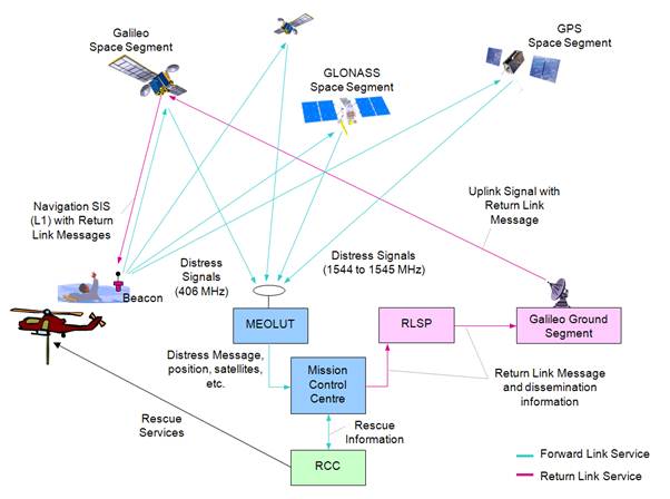
  • MEOSAR

    Cospas-Sarsat is in the process of upgrading its satellite system by placing search-and-rescue receivers (i.e., repeaters or transponders) on new GPS satellites operated by the United States, navigation satellites of Russia (GLONASS) that began deployment last year, and European GALILEO navigation satellites that began launching 12 October 2012. Once qualified as operational, this system augmentation will dramatically improve both the speed and location-accuracy for detecting beacons.

    Those satellites orbit the Earth at an altitude between 19,000 and 24,000 km, a range considered as medium-altitude Earth orbit. Hence this component of Cospas-Sarsat is known as the Medium-altitude Earth Orbit Search and Rescue system or MEOSAR. It will complement the existing LEOSAR and GEOSAR systems.

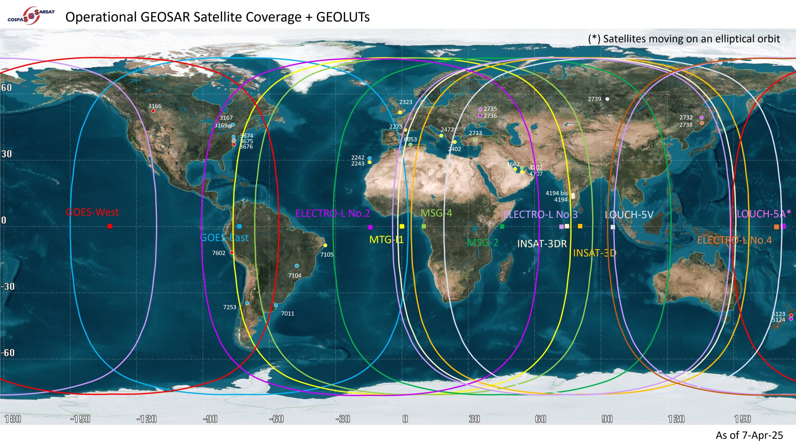
    The current LEOSAR and GEOSAR systems contribute respective advantages to the detection and location of distress beacons that have been activated. The GEOSAR system constantly covers the entire Earth except for the high-latitude (e.g., polar) regions. While the GEOSAR system can receive beacons distress messages across most of the globe, it cannot locate the beacon unless the location is encoded in the beacon’s message from a local navigation receiver. The LEOSAR system can locate a beacon without the aid of a GPS or other navigation signal to the beacon, but the LEOSAR satellites have a view of only a small part of the Earth at any given time, so there may be a delay in receiving the distress signal over LEOSAR.

    Once fully operational, the MEOSAR system will offer the advantages of both LEOSAR and GEOSAR systems without their current limitations by providing transmission of the distress message, and independent location of the beacon, with a near real-time worldwide coverage.

    The MEOSAR system also will facilitate other planned enhancements for Cospas-Sarsat beacons, such as a return link transmission that will allow the beacon to provide to the user a confirmation that the distress message has been received.

    The large number of MEOSAR satellites that will be in orbit when the system is fully operational will allow each distress message to be relayed at the same time by several satellites to several ground antennas, improving the likelihood of detection and the accuracy of the location determination.

    The MEOSAR System Concept

    MEOSAR concept 20121


This site is registered on wpml.org as a development site. Switch to a production site key to remove this banner.