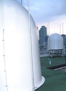
 There are three types of LUTs in the Cospas-Sarsat System, each corresponding to the type of satellite constellation that they operate with: LEOLUTs for the LEOSAR system, GEOLUTs for the GEOSAR system, and MEOLUTs for the MEOSAR system.
LEOLUT GEOLUT and MEOLUT operators provide the SAR community with reliable alert and location data without restriction on its use and distribution. The Cospas-Sarsat Space Segment Providers supply LUT operators with the System data that is required to operate their LUTs. To ensure that the data provided by LUTs is reliable and can be used by the SAR community on an operational basis, Cospas-Sarsat has developed LUT performance specifications and procedures. Copies of the LUT specifications (documents C/S T.002 for LEOLUTs, C/S T.009 for GEOLUTs and C/S T.019 for MEOLUTs) and commissioning standards (documents C/S T.005 for LEOLUTs, C/S T.010 for GEOLUTs and C/S T.020 for MEOLUTs) are available for download under the “System Documents” section of the Professionals website (Pro/Documents).
LEOLUTs
[Map of LEOLUT Locations]
The configuration and capabilities of each LEOLUT may vary to meet the specific requirements of the participating countries, but the Cospas and Sarsat LEOSAR spacecraft downlink signal formats ensure interoperability between the various spacecraft and all LEOLUTs meeting Cospas-Sarsat specifications.
The capability of a LEOLUT is determined, for the most part, by the LEOSAR satellite channels it was designed to process. There are a possible 2 channels that may, depending upon the specific satellite being tracked, be available for processing. Some satellites support all the channels listed below, and some only support a limited set of them.
-
The 406-MHz Search and Rescue Processor (SARP) satellite channel transmits received 406-MHz beacon data that has already been partially processed by the satellite to determine the identification, transmit time, and received frequency for each distress beacon transmission burst. Because of the on-board memory capability of the SARP channel, this channel provides global (yet not continuous) coverage for distress beacons that operate at 406 MHz.
-
The 406-MHz Search and Rescue Repeater (SARR) channel receives 406-MHz beacon transmission bursts and immediately retransmits them on the satellite downlink. Since there is no memory associated with the repeater channel, this type of processing supports only local mode coverage (i.e., the distress beacon and the LEOLUT must be in simultaneous view of the satellite for a period of time). Furthermore, since the satellite does not process the data, all the processing is performed by the LEOLUT.
For 406-MHz signals received via their respective SARR channel, each transmission is detected and the Doppler information calculated. A beacon position is then determined using this data. The LUT is also able to provide identification information associated with the beacon.
Processing the SARP channel 2400-bps data (i.e., those generated from 406-MHz transmissions) is relatively straightforward since the Doppler frequency is measured and time-tagged on-board the spacecraft. All 406-MHz data received from the satellite memory on each pass can be processed within a few minutes of pass completion.
To maintain accurate location processing, an update of the satellite ephemeris is produced each time the LUT receives a satellite signal. The downlink carrier is monitored to provide a Doppler signal using the LUT location as a reference, or highly stable 406-MHz calibration beacons at accurately known locations are used to update the ephemeris data.
GEOLUTs
[Map of GEOLUT Locations]
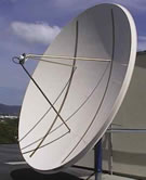 A GEOLUT is a ground receiving station in the Cospas-Sarsat System that receives and processes 406-MHz distress beacon signals which have been relayed by a Cospas-Sarsat geostationary satellite. Due to the extremely large continuous coverage footprint provided by each geostationary satellite, GEOLUTs are able to produce near-instantaneous alerting over extremely large areas. However, due to the fact that the satellite remains stationary with respect to distress beacons, GEOLUTs are not able to determine beacon locations using Doppler processing techniques. In view of this, 406-MHz beacons with location protocols allow for the encoding of GNSS position data in the transmitted 406-MHz message, thus providing for quasi-real-time alerting with position information via the GEOSAR system.
The “GEOLUT Availability Table” provides an indication of which GEOSAR satellite is tracked by which specific GEOLUT (Pro/System/System Monitoring/Availability Tables (QMS)).
MEOLUTs
[map of MEOLUT Locations] to come
[photo of a MEOLUT] to come
A MEOSAR Local User Terminal (MEOLUT) is a ground receiving station in the Cospas-Sarsat MEOSAR system that detects, characterizes and locates 406-MHz beacons, and forwards the beacon distress alert and location data to its associated Cospas-Sarsat Mission Control Centre (MCC).
The MEOLUT simultaneously tracks several medium earth orbiting (MEO) satellites of the BDS, Galileo, GPS and Glonass constellations that embark Search and Rescue (SAR) repeaters in addition to their primary GNSS payloads. The MEOLUT receives and processes the beacon signals relayed by those satellites and measures the received frequency and time of the beacon bursts. The MEOLUT calculates the uplink frequency of arrival (FOA) and time of arrival (TOA) of the detected beacon bursts at the satellite for each satellite channel. If the beacon burst is received from at least three MEOSAR satellites, the MEOLUT then calculates an unambiguous location for the beacon from the uplink TOA and FOA data. This methodology to determine beacon locations independently from GNSS signals is referred to as the Frequency Difference of Arrival/Time Difference of Arrival (FDOA/TDOA) location method. The MEOLUT can improve the accuracy of the beacon location over the first burst by combining data from subsequent bursts as they are received.
In addition, a MEOLUT may be exchanging data with other MEOLUTs, which allows increasing the number of TOA/FOA measurements used to locate beacons, thus increasing the beacon location accuracy and extending the coverage of the “networked” MEOLUTs.
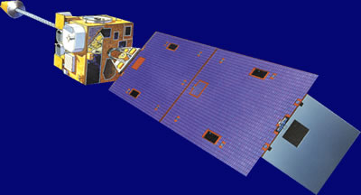 The GEOSAR system consists of 406 MHz repeaters carried on board various geostationary satellites, and the associated ground facilities called GEOLUTs which process the satellite signal.