Author: kevin

  • Step 3: Determine if ELT is a Location Protocol Beacon

    ELTs can be divided into two categories: location protocol ELTs and non-location protocol ELTs.

    A non-location protocol ELT does not have the capability to determine its own location, therefore, the distress position can only be determined by the Cospas-Sarsat System using Doppler location techniques.

    A location protocol ELT is able to determine its own location, normally using an internal or external satellite navigation device (e.g. GPS), and transmit this location information in the beacon’s message. In addition, location protocol beacons will also be located by the Cospas-Sarsat System using Doppler location techniques.

    An approved beacon model that is a location-protocol beacon will show a “Nav Device” available in its TAC Report, which can be viewed on the Professionals website (Pro/Beacons/Beacon Information/Approved Beacon Models (TACs)).

    Click on the appropriate beacon category to proceed to Step 4:

    For further details concerning beacons refer to the following documents (available for downloading):

    • C/S G.005, Cospas-Sarsat Guidelines on 406 MHz Beacon Coding, Registration and Type Approval,
    • C/S T.001, Specification for Cospas-Sarsat 406 MHz Distress Beacons.

    Return to Beacon Coding Tutorial Flow Chart

  • Step 2: Beacon Type

    There are many different beacon message protocols available. However, different protocols are defined for specific types of distress beacons. For example, a given protocol may be authorised for use with beacons installed on aircraft, but should not be used for beacons installed on maritime vessels.

    The choice of protocols is narrowed by the type of beacon to be coded. Select the type of beacon from the list below to proceed to step 3:

    • ELT – Emergency Locator Transmitter designed for installation on aircraft;
    • EPIRB – Emergency Position Indicating Radio Beacon designed for installation on maritime vessels;
    • PLB – Personal Locator Beacon designed to be carried by a person.

    Although it does not impact upon the selection of a beacon message protocol, beacon types can be further subdivided by their method of activation. In the aviation domain there are automatic and manual ELTs. Automatic ELTs are designed to be activated automatically using a crash sensor or G-switch, whereas manual ELTs can only be activated by the ELT operator. Similarly, in the maritime domain there are float free and non-float free beacons. Float-free beacons are designed to float away from a sinking vessel and activate automatically, whereas non-float-free beacons are activated manually.

    Later in the tutorial a detailed explanation of all beacon message protocols will be provided.

    Return to Beacon Coding Tutorial Flow Chart

  • Step 1: Contact your Country’s Administration

    States have the authority and responsibility to decide which beacon types, models and message protocols are authorised for use within their jurisdiction. Consequently, when considering which beacon message protocol would be most appropriate for your requirements, the first step should always be to contact the organization in your country responsible for distress beacon coding and registration to determine which beacon types (e.g. ELT, EPIRB, PLB), models, and message protocols are authorised or mandated. National Contacts for Beacon Matters are listed on the Professionals website (Pro/Contact Lists).

    Failure to take this step may result in the beacon not being accepted.

    Please advise the Cospas-Sarsat Secretariat at mail@cospas-sarsat.int if the point-of-contact information for your country is out of date.


    Proceed to Step 2

    Return to Beacon Coding Tutorial Flow Chart

  • Desactivación del Servicio de Alertas Cospas-Sarsat 121.5/243 MHz

    ¡Cambiar a 406 MHz!

    El Sistema Internacional Cospas-Sarsat cesó el procesamiento de balizas de 121.5/243 MHz el 1er de febrero de 2009. Todos los propietarios y usuarios de estas balizas deben reemplazarlas lo antes posible por balizas de 406 MHz.

    El Sistema de Satélites Cospas-Sarsat ya sólo detecta las balizas de 406 MHz. Esto afectará a todas las balizas tanto marítimas (EPIRBs), como aéreas (ELTs) y personales (PLBs). Sin embargo, otros dispositivos (tales como radiobalizas personales de hombre al agua y sistemas de localización guiada) que funcionan en 121.5 MHz y no están basados en detecciones por satélite no se ven afectados por la desactivación del procesado de los satélites en 121.5 MHz.

    La decisión de cesar el procesamiento de balizas de 121.5/243 MHz fue tomada in octubre del 2000 durante la 25a Sesión del Consejo Cospas-Sarsat (CSC-25).

    ¿Por qué cambiar?

    El Sistema Cospas-Sarsat tomó la decisión de cesar el procesamiento de balizas de 121.5/243 MHz como respuesta a las directrices marcadas por la Organización de Aviación Civil Internacional (OACI) y la Organización Marítima Internacional (OMI). Estas organizaciones de Naciones Unidas determinan los requisitos de seguridad para aeronaves y embarcaciones marítimas y han reconocido las limitaciones de las balizas de 121.5/243 MHz y la superioridad de las prestaciones del sistema de alertas de 406 MHz.

    Las balizas digitales de 406 MHz proporcionan muchas ventajas frente a las balizas analógicas de 121.5/243 MHz. Con una radiobaliza de 406 MHz, la posición de la emergencia se puede retransmitir a los servicios de rescate más rápidamente y con mayor fiabilidad y precisión.

    Baliza de 406 MHz Baliza de 121.5/243 MHz
    Señal Digital: identificación única, el registro proporciona información del propietario Analógica: no hay datos codificados, alta tasa de falsas alertas
    Potencia de la señal Pulsos de 5 W Señal continua de 0.1 W (típico)
    Cobertura Global Local
    Precisión de localización

    Inferior a 5 Km, si hay Doppler

    Inferior a 100 m, si la posición GNSS (GPS) está codificada en el mensaje

    Inferior a 20 Km (sólo posición Doppler)
    Tiempo de detección de la alerta Alerta GEO antes de 5 minutos Tiempo medio entre pases de satélites LEO, 45 minutos
    Resolución de ambigüedad de la posición debida al Doppler Posiblemente en el primer pase de satélite Se necesitan dos pases de satélites

    Sólo una de cada 50 alertas de balizas de 121.5/243 MHz es una situación de emergencia real. Esto afectó directamente a los recursos de los servicios de búsqueda y rescate (SAR). Con balizas de 406 MHz, las falsas alertas se han reducido considerablemente (una de cada 17 alertas es real) y si la baliza está registrada correctamente, las falsas alertas en muchas ocasiones se pueden resolver con una simple llamada telefónica al propietario de la baliza, utilizando el código de identificación de la misma. De esta forma, una alerta real puede recibir la atención que merece.

    Cuando se recibe una señal de una baliza de 406 MHz, las autoridades SAR pueden obtener información de una base de datos de registro de balizas. En la cual se incluye información de contacto del propietario de la baliza, información de contacto para emergencias, y características de identificación del barco o la aeronave. Tener esta información disponible, permite a los servicios SAR responder adecuadamente. ¡Asegúrese de que su baliza está registrada correctamente! [read more – solo disponible en inglés]


    Información más detallada:

    Para mayor información sobre el Cospas-Sarsat Phase Out Plan for 121.5/243 MHz Satellite Alerting Service, véase el documento C/S R.010 “Cospas-Sarsat Phase-Out Plan for 121.5/243 MHz Satellite Alerting” (solo disponible en inglés).


    Enlaces de interés:

    www.sarsat.noaa.gov/121phaseout.pdf

    www.amsa.gov.au

    www.safeboating.org.au

    www.equipped.com/uscgsarsat.htm


  • Alert Data Distribution

    The Cospas-Sarsat Data Distribution Plan

    The purpose of the Cospas-Sarsat Data Distribution Plan (document C/S A.001, “the DDP”) is to:

    • establish basic data distribution principles, and
    • define procedures to be implemented by Cospas-Sarsat Mission Control Centres (MCCs) for distributing Cospas-Sarsat alert data and System information.

    The annexes to the DDP provide:

    • a description of the Cospas-Sarsat Space and Ground Segments (Part I), and
    • a detailed description of the operational procedures to be applied by MCCs (Part II).

    Data Distribution

    Cospas-Sarsat alert data generated by LEOLUTs and GEOLUTs are distributed to the appropriate Rescue Coordination Centre (RCC) or Search and Rescue Point of contact (SPOC), according to the computed position of the distress and/or the country code of the beacon. Due to the high degree of redundancy in the Cospas-Sarsat Ground Segment (each operational LUT is capable of providing essentially the same data in the global mode of operation), such distribution must be coordinated and redundant data filtered out of the ground communication network. Each LUT is linked to an associated Mission Control Centre (MCC) and alert messages are forwarded to the appropriate RCC/SPOC through the MCC communication network, in accordance with the procedures described in the Cospas-Sarsat Data Distribution Plan (C/S A.001) (available under the “System Documents” section of our Professionals website – Pro/Documents).
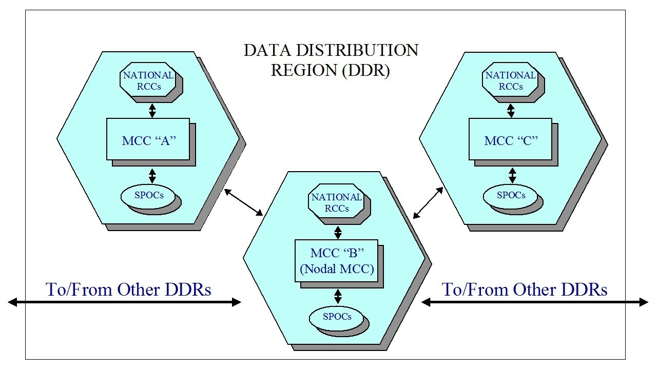
    DDRalertdatadistribution

    For the purpose of distributing alerts, Cospas-Sarsat has established six data distribution regions (DDRs), each supported by a nodal MCC. Within each DDR there may be several MCCs responsible for the distribution of alerts for a specific geographic area (MCC service area). Alerts are routed by the Cospas-Sarsat data distribution network to the MCC whose service area supports the region where the alert was located. It is that MCC’s responsibility to forward the alert to the appropriate RCC or SPOC. Alerts that must be distributed beyond DDR boundaries are routed via nodal MCCs, and then on to the MCC responsible for the service area concerned. Cospas-Sarsat also sends the alert message to the RCC/SPOC associated with the country code of the beacon.


    Cospas-Sarsat MCC Service Area

    Each Cospas-Sarsat MCC is responsible for distributing all alert data for distresses incidents located in its service area. An MCC service area generally includes aeronautical and maritime Search and Rescue Regions (SRRs) in which the MCC’s national authorities facilitate or provide SAR services, and includes in addition such regions of other countries with which the MCC’s national authorities have appropriate agreements for the provision of Cospas-Sarsat alert data.

    MCC Service Areas are established following coordination among Cospas-Sarsat Ground Segment Providers (i.e., LUT-MCC Operators), working bi-laterally, taking into account:

    • geographical location and common SRR boundaries,

    • communication capabilities,

    • existing national SAR arrangements and existing bilateral operational agreements.

    Agreed MCC Service Areas are described in the Cospas-Sarsat Data Distribution Plan. When a Cospas-Sarsat beacon transmission is located outside the service area of the MCC that receives the alert, the alert message is either forwarded to the MCC serving the area where the distress has been located, or is filtered out if the alert data has already been received through another LUT/MCC.


    Message Formats

    Cospas-Sarsat alert messages are exchanged among MCCs according to standardized message formats. The detailed structure of messages for distribution of alert data and system information are described in document C/S A.002 “Cospas-Sarsat Mission Control Centres Standard Interface Description (SID)” (available under the “System Documents” section of our Professionals website).


    Communication Links

    The Cospas-Sarsat SID formats have been defined to allow for the transmission of alert messages on any communication system as agreed between MCCs and between a Cospas-Sarsat MCC and its associated RCCs or SPOCs. Alert messages in SID formats can be routed and processed by MCCs automatically.

    In addition to telephone (voice and/or facsimile) communications, all Cospas-Sarsat MCCs are required to have access to at least two international data networks for transmitting alert messages in order to provide maximum availability and adequate flexibility for the exchange of alert data. MCCs transmit alert data to other MCCs, SPOCs or RCCs using the following systems:

    • Automatic Fixed Telecommunication Network (AFTN) of Civil Aviation,

    • File Transfer Protocol over Virtual Private Network (FTP-VPN),

    • Facsimile/email (for SPOC/RCC communications only).

    AFTN addresses, telephone or facsimile numbers are provided on the Contacts page of the Cospas-Sarsat Professionals website (http://www.cospas-sarsat.int/en/contacts-pro/contacts-details-all). Coordination between the MCC operator and SPOCs in its service area to agree on communication systems and interfaces to be used is strongly encouraged.

    To ensure that Cospas-Sarsat alert and location data is distributed efficiently, IMO and ICAO have invited each of their Member states to designate a national SPOC and to provide the required information on available communication links either to IMO, ICAO, or the Cospas-Sarsat Secretariat.

    Cospas-Sarsat has also made available a template for a model agreement for cooperation between MCCs and SPOCs (https://www.cospas-sarsat.int/en/documents-pro/document-templates, under the System Documents tab on that page).

  • What information do I need before I can complete the online registration of my beacon?

    The IBRD has 12 required fields. 

    You must fill these fields in order to have your registration accepted in the IBRD:

    Beacon ID
    Password (You will be asked to create a password)
    Owner Name
    Owner phone number
    Owner phone number type (for example: home, cell, work, fax, other)
    Emergency contact Name
    Emergency contact phone number
    Emergency contact phone number type (for example: home, cell, work, fax, other)
    Vehicle Type (Selectable from a list)
    Vehicle Name (not required for PLB)
    MMSI / Call Sign / Inmarsat Number / vessel cell phone number (at least one, for EPIRB only)
    Vehicle Registration Number (not required for PLB)

    For security reasons, the online registration form expires after 20 minutes.  In order to make registration easy, you may wish to gather all the information needed to complete the required fields before you begin the online registration process.

  • Bulk Upload Software

    National Data Providers are invited to use this Beta version of a bulk upload software that allows Administrations to easily save beacon records locally and upload the local beacon registry to the IBRD.

    To install the application, please download the following file. To install and use the application, Java must be installed first.

    Read full user guide to use the software.

    Click here to download Bulk Upload.zip

    Save the zipped file to your computer. Unzip locally.

    To start the installation, open the file install.bat. If this fails you can open install.jar.

    ***New release on 15 April 2009***

    Please re-install with the above version if you already have it installed.
    Fixed “State/Province” field for upload to the IBRD.

    To install Java, please go to www.java.com.

  • Participation in Meetings

    Cospas-Sarsat meetings are open only to designated representatives of the Administrations formally associated with the Programme and invited representatives of International Organisations.

    Simultaneous translation to and from the three languages of the Programme is provided at Council meetings. Meetings of subsidiary organs will normally be held in the English language only, with no interpretation (i.e., Joint Committees, Task Groups, Experts Working Groups).

     [module-210]
  • Mission Control Centres (MCCs)

    [ List and map of MCCs ]

    [ MCC Contact Information ]

    MCCs have been set up in most countries operating at least one LUT. Their main functions are to:

    • collect, store and sort the data from LUTs and other MCCs;

    • provide data exchange within the Cospas-Sarsat System; and

    • distribute alert and location data to associated RCCs or SPOCs.

    Most of the data fall into two general categories : alert data and system information.

    Alert data is the generic term for Cospas-Sarsat 406 MHz data derived from distress beacons. 406 MHz beacons alert data comprise the beacon location and coded information.

    System information is used primarily to keep the Cospas-Sarsat System operating at peak effectiveness and to provide users with accurate and timely alert data. It consists of satellite ephemeris and time calibration data used to determine beacon locations, the current status of the space and ground segments and coordination messages required to operate the Cospas-Sarsat System.

    All MCCs in the System are interconnected through appropriate networks for the distribution of System information and alert data. To ensure data distribution reliability and integrity, Cospas-Sarsat has developed MCC performance specifications (document C/S A.005) and MCC commissioning procedures (document C/S A.006). Reports on MCC operations are provided by MCC Operators on an annual basis. World-wide exercises are performed from time to time to check the operational status and performance of all LUTs and MCCs, and data exchange procedures.


This site is registered on wpml.org as a development site. Switch to a production site key to remove this banner.