Author: kevin

  • Step 1: Contact your Country’s Administration

    States have the authority and responsibility to decide which beacon types, models and message protocols are authorised for use within their jurisdiction. Consequently, when considering which beacon message protocol would be most appropriate for your requirements, the first step should always be to contact the organization in your country responsible for distress beacon coding and registration to determine which beacon types (e.g. ELT, EPIRB, PLB), models, and message protocols are authorised or mandated. National Contacts for Beacon Matters are listed on the Professionals website (Pro/Contact Lists).

    Failure to take this step may result in the beacon not being accepted.

    Please advise the Cospas-Sarsat Secretariat at mail@cospas-sarsat.int if the point-of-contact information for your country is out of date.


    Proceed to Step 2

    Return to Beacon Coding Tutorial Flow Chart

  • Desactivación del Servicio de Alertas Cospas-Sarsat 121.5/243 MHz

    ¡Cambiar a 406 MHz!

    El Sistema Internacional Cospas-Sarsat cesó el procesamiento de balizas de 121.5/243 MHz el 1er de febrero de 2009. Todos los propietarios y usuarios de estas balizas deben reemplazarlas lo antes posible por balizas de 406 MHz.

    El Sistema de Satélites Cospas-Sarsat ya sólo detecta las balizas de 406 MHz. Esto afectará a todas las balizas tanto marítimas (EPIRBs), como aéreas (ELTs) y personales (PLBs). Sin embargo, otros dispositivos (tales como radiobalizas personales de hombre al agua y sistemas de localización guiada) que funcionan en 121.5 MHz y no están basados en detecciones por satélite no se ven afectados por la desactivación del procesado de los satélites en 121.5 MHz.

    La decisión de cesar el procesamiento de balizas de 121.5/243 MHz fue tomada in octubre del 2000 durante la 25a Sesión del Consejo Cospas-Sarsat (CSC-25).

    ¿Por qué cambiar?

    El Sistema Cospas-Sarsat tomó la decisión de cesar el procesamiento de balizas de 121.5/243 MHz como respuesta a las directrices marcadas por la Organización de Aviación Civil Internacional (OACI) y la Organización Marítima Internacional (OMI). Estas organizaciones de Naciones Unidas determinan los requisitos de seguridad para aeronaves y embarcaciones marítimas y han reconocido las limitaciones de las balizas de 121.5/243 MHz y la superioridad de las prestaciones del sistema de alertas de 406 MHz.

    Las balizas digitales de 406 MHz proporcionan muchas ventajas frente a las balizas analógicas de 121.5/243 MHz. Con una radiobaliza de 406 MHz, la posición de la emergencia se puede retransmitir a los servicios de rescate más rápidamente y con mayor fiabilidad y precisión.

    Baliza de 406 MHz Baliza de 121.5/243 MHz
    Señal Digital: identificación única, el registro proporciona información del propietario Analógica: no hay datos codificados, alta tasa de falsas alertas
    Potencia de la señal Pulsos de 5 W Señal continua de 0.1 W (típico)
    Cobertura Global Local
    Precisión de localización

    Inferior a 5 Km, si hay Doppler

    Inferior a 100 m, si la posición GNSS (GPS) está codificada en el mensaje

    Inferior a 20 Km (sólo posición Doppler)
    Tiempo de detección de la alerta Alerta GEO antes de 5 minutos Tiempo medio entre pases de satélites LEO, 45 minutos
    Resolución de ambigüedad de la posición debida al Doppler Posiblemente en el primer pase de satélite Se necesitan dos pases de satélites

    Sólo una de cada 50 alertas de balizas de 121.5/243 MHz es una situación de emergencia real. Esto afectó directamente a los recursos de los servicios de búsqueda y rescate (SAR). Con balizas de 406 MHz, las falsas alertas se han reducido considerablemente (una de cada 17 alertas es real) y si la baliza está registrada correctamente, las falsas alertas en muchas ocasiones se pueden resolver con una simple llamada telefónica al propietario de la baliza, utilizando el código de identificación de la misma. De esta forma, una alerta real puede recibir la atención que merece.

    Cuando se recibe una señal de una baliza de 406 MHz, las autoridades SAR pueden obtener información de una base de datos de registro de balizas. En la cual se incluye información de contacto del propietario de la baliza, información de contacto para emergencias, y características de identificación del barco o la aeronave. Tener esta información disponible, permite a los servicios SAR responder adecuadamente. ¡Asegúrese de que su baliza está registrada correctamente! [read more – solo disponible en inglés]


    Información más detallada:

    Para mayor información sobre el Cospas-Sarsat Phase Out Plan for 121.5/243 MHz Satellite Alerting Service, véase el documento C/S R.010 “Cospas-Sarsat Phase-Out Plan for 121.5/243 MHz Satellite Alerting” (solo disponible en inglés).


    Enlaces de interés:

    www.sarsat.noaa.gov/121phaseout.pdf

    www.amsa.gov.au

    www.safeboating.org.au

    www.equipped.com/uscgsarsat.htm


  • Alert Data Distribution

    The Cospas-Sarsat Data Distribution Plan

    The purpose of the Cospas-Sarsat Data Distribution Plan (document C/S A.001, “the DDP”) is to:

    • establish basic data distribution principles, and
    • define procedures to be implemented by Cospas-Sarsat Mission Control Centres (MCCs) for distributing Cospas-Sarsat alert data and System information.

    The annexes to the DDP provide:

    • a description of the Cospas-Sarsat Space and Ground Segments (Part I), and
    • a detailed description of the operational procedures to be applied by MCCs (Part II).

    Data Distribution

    Cospas-Sarsat alert data generated by LEOLUTs and GEOLUTs are distributed to the appropriate Rescue Coordination Centre (RCC) or Search and Rescue Point of contact (SPOC), according to the computed position of the distress and/or the country code of the beacon. Due to the high degree of redundancy in the Cospas-Sarsat Ground Segment (each operational LUT is capable of providing essentially the same data in the global mode of operation), such distribution must be coordinated and redundant data filtered out of the ground communication network. Each LUT is linked to an associated Mission Control Centre (MCC) and alert messages are forwarded to the appropriate RCC/SPOC through the MCC communication network, in accordance with the procedures described in the Cospas-Sarsat Data Distribution Plan (C/S A.001) (available under the “System Documents” section of our Professionals website – Pro/Documents).

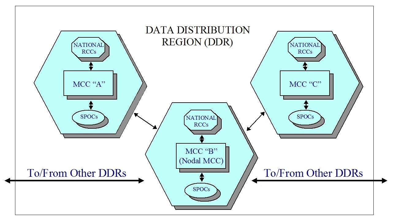
    DDRalertdatadistribution

    For the purpose of distributing alerts, Cospas-Sarsat has established six data distribution regions (DDRs), each supported by a nodal MCC. Within each DDR there may be several MCCs responsible for the distribution of alerts for a specific geographic area (MCC service area). Alerts are routed by the Cospas-Sarsat data distribution network to the MCC whose service area supports the region where the alert was located. It is that MCC’s responsibility to forward the alert to the appropriate RCC or SPOC. Alerts that must be distributed beyond DDR boundaries are routed via nodal MCCs, and then on to the MCC responsible for the service area concerned. Cospas-Sarsat also sends the alert message to the RCC/SPOC associated with the country code of the beacon.


    Cospas-Sarsat MCC Service Area

    Each Cospas-Sarsat MCC is responsible for distributing all alert data for distresses incidents located in its service area. An MCC service area generally includes aeronautical and maritime Search and Rescue Regions (SRRs) in which the MCC’s national authorities facilitate or provide SAR services, and includes in addition such regions of other countries with which the MCC’s national authorities have appropriate agreements for the provision of Cospas-Sarsat alert data.

    MCC Service Areas are established following coordination among Cospas-Sarsat Ground Segment Providers (i.e., LUT-MCC Operators), working bi-laterally, taking into account:

    • geographical location and common SRR boundaries,

    • communication capabilities,

    • existing national SAR arrangements and existing bilateral operational agreements.

    Agreed MCC Service Areas are described in the Cospas-Sarsat Data Distribution Plan. When a Cospas-Sarsat beacon transmission is located outside the service area of the MCC that receives the alert, the alert message is either forwarded to the MCC serving the area where the distress has been located, or is filtered out if the alert data has already been received through another LUT/MCC.


    Message Formats

    Cospas-Sarsat alert messages are exchanged among MCCs according to standardized message formats. The detailed structure of messages for distribution of alert data and system information are described in document C/S A.002 “Cospas-Sarsat Mission Control Centres Standard Interface Description (SID)” (available under the “System Documents” section of our Professionals website).


    Communication Links

    The Cospas-Sarsat SID formats have been defined to allow for the transmission of alert messages on any communication system as agreed between MCCs and between a Cospas-Sarsat MCC and its associated RCCs or SPOCs. Alert messages in SID formats can be routed and processed by MCCs automatically.

    In addition to telephone (voice and/or facsimile) communications, all Cospas-Sarsat MCCs are required to have access to at least two international data networks for transmitting alert messages in order to provide maximum availability and adequate flexibility for the exchange of alert data. MCCs transmit alert data to other MCCs, SPOCs or RCCs using the following systems:

    • Automatic Fixed Telecommunication Network (AFTN) of Civil Aviation,

    • File Transfer Protocol over Virtual Private Network (FTP-VPN),

    • Facsimile/email (for SPOC/RCC communications only).

    AFTN addresses, telephone or facsimile numbers are provided on the Contacts page of the Cospas-Sarsat Professionals website (http://www.cospas-sarsat.int/en/contacts-pro/contacts-details-all). Coordination between the MCC operator and SPOCs in its service area to agree on communication systems and interfaces to be used is strongly encouraged.

    To ensure that Cospas-Sarsat alert and location data is distributed efficiently, IMO and ICAO have invited each of their Member states to designate a national SPOC and to provide the required information on available communication links either to IMO, ICAO, or the Cospas-Sarsat Secretariat.

    Cospas-Sarsat has also made available a template for a model agreement for cooperation between MCCs and SPOCs (https://www.cospas-sarsat.int/en/documents-pro/document-templates, under the System Documents tab on that page).

  • What information do I need before I can complete the online registration of my beacon?

    The IBRD has 12 required fields

    You must fill these fields in order to have your registration accepted in the IBRD:

    Beacon ID
    Password (You will be asked to create a password)
    Owner Name
    Owner phone number
    Owner phone number type (for example: home, cell, work, fax, other)
    Emergency contact Name
    Emergency contact phone number
    Emergency contact phone number type (for example: home, cell, work, fax, other)
    Vehicle Type (Selectable from a list)
    Vehicle Name (not required for PLB)
    MMSI / Call Sign / Inmarsat Number / vessel cell phone number (at least one, for EPIRB only)
    Vehicle Registration Number (not required for PLB)

    For security reasons, the online registration form expires after 20 minutes.  In order to make registration easy, you may wish to gather all the information needed to complete the required fields before you begin the online registration process.

  • Bulk Upload Software

    National Data Providers are invited to use this Beta version of a bulk upload software that allows Administrations to easily save beacon records locally and upload the local beacon registry to the IBRD.

    To install the application, please download the following file. To install and use the application, Java must be installed first.

    Read full user guide to use the software.

    Click here to download Bulk Upload.zip

    Save the zipped file to your computer. Unzip locally.

    To start the installation, open the file install.bat. If this fails you can open install.jar.

    ***New release on 15 April 2009***

    Please re-install with the above version if you already have it installed.
    Fixed “State/Province” field for upload to the IBRD.

    To install Java, please go to www.java.com.

  • Participation in Meetings

    Cospas-Sarsat meetings are open only to designated representatives of the Administrations formally associated with the Programme and invited representatives of International Organisations.

    Simultaneous translation to and from the three languages of the Programme is provided at Council meetings. Meetings of subsidiary organs will normally be held in the English language only, with no interpretation (i.e., Joint Committees, Task Groups, Experts Working Groups).

     [module-210]
  • Mission Control Centres (MCCs)

    [ List and map of MCCs ]

    [ MCC Contact Information ]

    MCCs have been set up in most countries operating at least one LUT. Their main functions are to:

    • collect, store and sort the data from LUTs and other MCCs;

    • provide data exchange within the Cospas-Sarsat System; and

    • distribute alert and location data to associated RCCs or SPOCs.

    Most of the data fall into two general categories : alert data and system information.

    Alert data is the generic term for Cospas-Sarsat 406 MHz data derived from distress beacons. 406 MHz beacons alert data comprise the beacon location and coded information.

    System information is used primarily to keep the Cospas-Sarsat System operating at peak effectiveness and to provide users with accurate and timely alert data. It consists of satellite ephemeris and time calibration data used to determine beacon locations, the current status of the space and ground segments and coordination messages required to operate the Cospas-Sarsat System.

    All MCCs in the System are interconnected through appropriate networks for the distribution of System information and alert data. To ensure data distribution reliability and integrity, Cospas-Sarsat has developed MCC performance specifications (document C/S A.005) and MCC commissioning procedures (document C/S A.006). Reports on MCC operations are provided by MCC Operators on an annual basis. World-wide exercises are performed from time to time to check the operational status and performance of all LUTs and MCCs, and data exchange procedures.


  • System Data

    The Cospas-Sarsat System Data document provides the following information:

    • Statistics on the number of SAR events and persons rescued assisted by information from Cospas-Sarsat

    • System coverage maps

    • Space and Ground Segment equipment availability

    • Type approved 406 MHz beacons

    • Estimated 406 MHz beacon population

    • The list of countries and organisations that manage the Programme and operate the System

    Untitled Document


    C/S Ref.

    Language

    Document Title

    Dated

    SD 38

    English

    System Data Document

    Dec 2012

    Русский

    Сведения о Системе Коспас-Сарсат

    Français

    Donnée relatives au Système Cospas-Sarsat

  • Acronyms and Terminology

    Acronym 

    Term

    Definition

    A/D

    Analogue/Digital


    ACC

    Area Control Centre


    ACHA

    Advisory Committee on the History of Cooperation in Space Activities 


    AEMCC

    United Arab Emirates MCC


    AFTN

    Aeronautical Fixed Telecommunication Network


    AGC

    Automatic Gain Control


    AI

    Action Item


    AIS

    Automatic Identification System


    ALC

    Automatic Level Control


    ALE Average Location Error  
    ALMCC Algerian MCC  
    AM Amplitude Modulation  
    AMSA Australian Maritime Safety Authority  
    AMSS Aeronautical Mobile-Satellite Service  
    AOS Acquisition of Signal  
    APSAR/TF Asia/Pacific Search and Rescue Task Force  
    ARCC Aeronautical Rescue Coordination Centre  
    ARMCC Argentine MCC  
    ASMCC  South African MCC   
    ATC Air Traffic Control  
    AUMCC Australian MCC  
    Az Azimuth  
    BASARNAS National SAR Agency of Indonesia   
    BCD Binary-Coded Decimal  
    BCH Bose-Choudhuri-Hocquenghem  
    BCN Beacon  
    BER Bit Error Rate  
    BIH Bureau International de l’Heure  

    bps

    Bits per second

    Bits par seconde


    BRMCC

    Brazilian MCC


    BW

    Bandwidth


    C/N

    Carrier-to-Noise Ratio


    C/N0

    Carrier-to-Noise Density Ratio


    C/S

    Cospas-Sarsat


    CDA

    Command and Data Acquisition Station (NOAA)


    CDARS

    Cooperative Data and Rescue Services


    CDDR

    Central DDR


    CDR

    Critical Design Review


    CEP

    Circular Error Probable


    CHMCC

    Chilean MCC


    CIRM

    Comité International Radio-Maritime

    International Radio-Maritime Committee

    CISPR

    International Special Committee on Radio Interference


    CLD

    Closed 

    Closed Meeting of a CSC Session

    CMC

    Cospas Mission Centre (Russian Federation)


    CMCC

    Canadian MCC


    CNES

    Centre National d’Etudes Spatiales (France)


    Cospas

    “Cosmicheskaya Sistyema Poiska Avariynich Sudov”

    Russian words meaning “Space System for the Search of Vessels in Distress”

    Système spatial pour les recherches des navires en détresse (sigle dérivé du russe)

    CSC

    Cospas-Sarsat Council

    Conseil Cospas-Sarsat

    dB

    Decibel

    Décibel


    DND

    Department of National Defence (Canada)

    Ministère de la Défense nationale (Canada)

    ELT

    Emergency Locator Transmitter

    Aeronautical distress beacon

    Emetteur de localisation d’urgence (balises de détresse aéronautiques)


    Ephémérides

    Données relatives à la position et à la vitesse du satellite qui permettent le calcul des positions du satellite à tout instant


    Ephemeris

    Satellite position and velocity data that allows the satellite position to be calculated at any point in time

    EPIRB

    Emergency Position Indicating Radio Beacon

    Maritime distress beacon

    Radiobalise de localisation de sinistre (RLS – balises de détresses maritimes)

    GEOLUT

    Geostationary Earth Orbit Local User Terminal

    A Ground receiving station in the Cospas-Sarsat GEOSAR System that detects, processes, and recovers the coded transmissions of 406 MHz emergency distress beacons, and relays the appropriate information to an MCC

    Station de réception au sol dans le système GEOSAR Cospas-Sarsat, qui détecte, traite et récupère les émissions codées des balises de détresse à 406 MHz, et relaie les informations adéquates à un MCC

    GEOSAR

    Geostationary Earth Orbit Search and Rescue

    Satellite system at 406 MHz

    Système de satellites géostationnaires à 406 MHz pour les recherches et le sauvetage

    Hz

    Hertz


    ICAO

    International Civil Aviation Organization

    Organisation de l’Aviation Civile Internationale (voir OACI)

    IMO

    International Maritime Organization

    Organisation Maritime Internationale (voir OMI)

    ITU

    International Telecommunication Union

    Union Internationale des Télécommunications (voir UIT)

    kHz

    Kilohertz


    LEOLUT

    Low Earth Orbit Local User Terminal

    A ground receiving station in the Cospas-Sarsat LEOSAR system that detects, characterises and locates emergency beacons, and forwards the appropriate information to an MCC

    Station de réception au sol dans le système LEOSAR Cospas-Sarsat, qui détecte, identifie et localise les balises de détresse, et envoie les informations adéquates à un MCC

    LEOSAR

    Low Earth Orbit Search and Rescue

    Satellite system in polar orbit

    Système de satellites en orbite polaire basse pour les recherches et le sauvetage

    LUT

    Local User Terminal

    Cospas-Sarsat ground receiving station

    Station terrienne d’utilisateur local (station Cospas-Sarsat de réception au sol)

    MCC

    Mission Control Centre

    Cospas-Sarsat Mission Control Centre

    Centre de contrôle de mission Cospas-Sarsat

    MHz

    Megahertz

    Mégahertz

    Radio frequency

    Fréquence radio


    MORSVIAZSPUTNIK

    Russian agency responsible for maritime navigation and mobile satellite communications at sea and on land

    NOAA

    National Oceanic and Atmospheric Administration (USA)


    NSS

    National Search and Rescue Secretariat (Canada)

     Secrétariat National – Recherche et Sauvetage (Canada), voir SNR

    OACI

    Organisation de l’Aviation Civile Internationale

    International Civil Aviation Organization (see ICAO)

    OMI

    Organisation Maritime Internationale

    International Maritime Organization (see IMO)

    PAIS

    Primary Air Information Stations


    PLB

    Personal Locator Beacon

    Balise de localisation personnelle

    RCC

    Rescue Coordination Centre

    Centre de coordination de sauvetage

    RF

    Radio Frequency


    RLS

    Radiobalise de localisation de sinistre

    Balises de détresses maritimes, voir aussi EPIRB

    RSFTA

    Réseau du service fixe des télécommunications aéronautiques


    SAIS

    Secondary Air Information Stations


    SAR

    Search and Rescue

    Recherches et Sauvetage

    SARP

    Search and Rescue Processor

    Processeur SAR

    Sarsat

    Search and Rescue Satellite-Aided Tracking

    Système d’aide aux recherches et au sauvetage par satellite

    SEU

    Single Event Upset


    SNR

    Secrétariat National – Recherche et Sauvetage (Canada)

    National Search and Rescue Secretariat (Canada), see NSS

    SPOC

    SAR Point of Contact

    Point de contact SAR

    SRR

    Search and Rescue Region

    Région de responsabilité SAR

    UIT

    Union Internationale des Télécommunications

    International Telecommunication Union (see ITU)

    А

    АРБ (EPIRB)

    Аварийный радиобуй-указатель местоположения (морской аварийный радиобуй)

    А

    АРМ (ELT)

    Аварийный передатчик-указатель положения (авиационный аварийный радиобуй)

    А

    АФТН (AFTN)

    Сеть авиационной фиксированной связи

    Б

    бит/сек (bps)

    Бит в секунду

    Г

    ГЕOСПОИ (GEOLUT)

    Наземная приемная станция в Системе Коспас-Сарсат ГССПС, которая обнаруживает и обрабатывает закодированные сообщения от аварийных радиобуев 406 МГц, а также передает соответствующую информацию в КЦС

    Г

    ГОСПС (GEOSAR)

    Геостанционарная спутниковая система поиска и спасания (406 МГц)

    Г

    Гц (Hz)

    Герц

    Д

    ДБ (dB)

    Децибел

    Д

    ДНД (DND)

    Министерство национальной обороны Канады

    И

    ИКАО (IMO)

    Международная организация гражданской авиации

    И

    ИМО

    Международная морская организация

    К

    КГц (kHz)

    Килогерц

    К

    КНЕС (CNES)

    Национальный центр по исследованию космоса (Франция)

    К

    Коспас (Cospas)

    Космическая система поиска аварийных судов (Россия)

    К

    КЦС (МСС)

    Координационный центр системы

    М

    МГц (MHz)

    Мегагерц

    М

    Морсвязьспутник (Morsvizsputnik)

    Государственное предприятие электронавигации и спутниковой связи Министерства транспорта и связи (Россия)

    М

    МСЭ (ITU)

    Международный союз электросвязи

    Н

    НИОСПОИ (LEOLUT)

    Наземная приемная станция в системе Коспас-Сарсат НССПС, которая обнаруживает и определяет местоположение аварийных радиобуев, а также передает соответствующую информацию в КЦС

    Н

    НОАА (NOAA)

    Национальное управление по океанам и атмосфере (США)

    Н

    НСС (NSS)

    Национальный Секретариат по поиску и спасанию (Канада)

    Н

    НССПС (LEOSAR)

    Низкоорбитальная спутниковая система поиска и спасания (с приполярной орбитой спутников)

    П

    ПОСПС (SARP)

    Процессор обработки сигналов поиска и спасания

    П

    ПРБ (PLB)

    Персональный радиобуй (аварийный радиобуй для использования на суше)

    П

    ПС (SAR)

    Поиск и спасание

    П

    ПСР (SRR)

    Поисково-спасательный район

    Р

    РЧ (RF)

    Радиочастота

    С

    Сарсат (Sarsat)

    Спутниковая система поиска и спасания

    С

    СКС (CSC)

    Совет Коспас-Сарсат

    С

    СКЦ (RCC)

    Спасательно-координационный центр

    С

    СПОИ (LUT)

    Станция приема и обработки информации (наземная приемная станция Коспас-Сарсат)

    Т

    ТКПС (SPOC)

    Точка контакта для поиска и спасания

    Э

    Эфемериды (Ephemeris)

    Данные о перемещении спутника и его скорости, которые позволяют рассчитать его положение в любой момент времени

This site is registered on wpml.org as a development site. Switch to a production site key to remove this banner.